
Flooding has been and remains the number one natural disaster problem for the United States. This fact has been proven over decades of observation of natural catastrophes. Houston, like all of Texas, is in a high-risk zone. Its proximity to the Gulf of Mexico, flat terrain, and extensive river network all contribute to the formation of floods. To mitigate damage and save lives, the authorities have developed a comprehensive flood control system for the region. We’ll detail this system next on houstoname.
The Sobering Numbers
From 1980 to 2020, Houston saw a significant increase in major floods and hurricanes. Many factors contributed to this, with climate change and human impact on nature being the primary drivers.
To illustrate the seriousness of Houston’s flood problem, here is a breakdown of major events:
| Hurricane or Flood Name | Year | Fatalities | Damages (in billions USD) | Key Features |
| Hurricane Alicia | 1983 | 21 | 2.6 | Rapid intensification just before landfall |
| Tropical Storm Allison | 2001 | 23 | 5.0 | Extremely heavy rainfall over several days |
| Hurricane Rita | 2005 | 7 | 12.0 | The most intense Atlantic hurricane on record at the time |
| Hurricane Ike | 2008 | 84 | 29.5 | Devastating storm surge that flooded coastal areas |
| April Floods | 2016 | 8 | 1.0 | Sudden and severe flooding from powerful downpours |
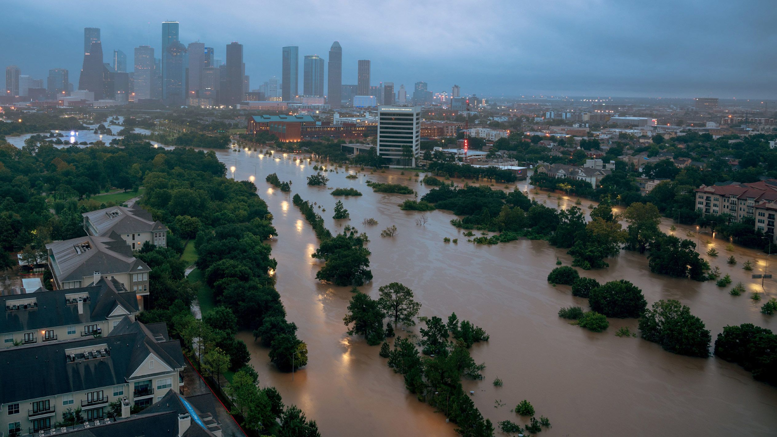
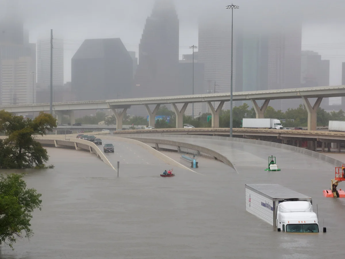
| Hurricane Harvey | 2017 | 68 | 125.0 | Extreme rainfall leading to catastrophic, widespread flooding |
These are only the largest events over the last 40 years. Less devastating, though still costly, floods occur much more frequently. This struggle against disaster has been ongoing since Houston’s very founding.
The Consequences of Urbanization
The problem of flooding has always existed, but nature once managed the process skillfully. The land has an amazing ability to retain, slow down, and absorb water. When settlers first arrived on the banks of Buffalo Bayou, the surrounding prairies stretched for hundreds of miles. Along the shores were hundreds of wetlands that naturally regulated the water flow.
Changes began with Houston’s growth, particularly with the city’s rapid expansion. The region thrived economically thanks to cotton and oil, leading to a surge in population and a demand for housing. Gradually, wetlands were drained for construction. The natural “earth sponge” that once held excess water was destroyed.
According to Houston Wilderness, less than 1% of the 6.5 million acres of coastal prairie that once existed along the Texas coast remain today. In Houston, the population sharply increased between 1992 and 2010. During this time, the city lost at least 5.5% of its natural freshwater wetlands, and Harris County lost a staggering 30%. As a result, even rain lasting a few days poses a significant problem for the region. Imagine what hurricanes can do.
Attempts at Flood Control
Once flooding problems emerged, they began inflicting significant damage on the city. After the devastating floods of 1929 and 1935, authorities began searching for solutions.
Monitoring and Warning
In 1937, a special department was created for monitoring, forecasting, and controlling floods in Harris County—the Flood Warning System (FWS). Their oversight includes 22 different waterways that can potentially cause flooding. Each waterway is subject to separate, real-time monitoring and observation.
As a result of years of observation, hydrological specialists developed a flood warning system that became fully operational in 1982. When it started, it included only 13 stations. By 2024, that number had grown to 139. When the risk of inundation arises, the public is immediately notified of the danger. However, this system only helps to warn people; it cannot mitigate the effects of the flood itself. Therefore, other flood regulation methods were developed alongside the FWS.
Dams and Reservoirs
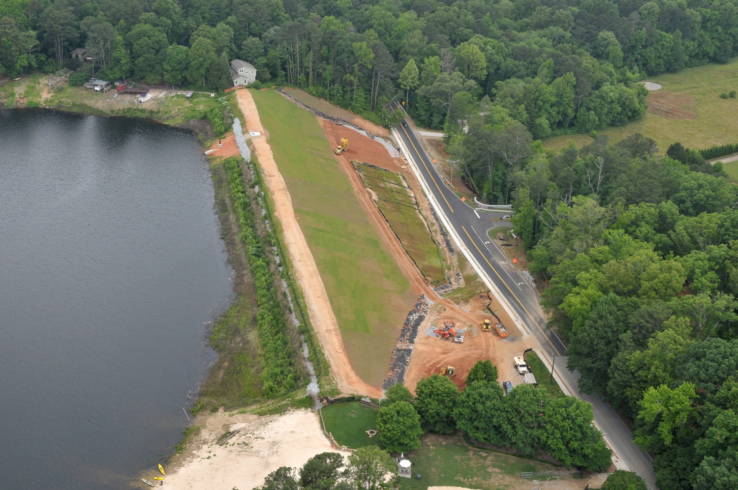
In the first half of the 20th century, two major dams were built near Houston. The Barker Dam was completed in 1945, followed three years later by the Addicks Dam in 1948. Both were designed to protect western Houston from flooding on Buffalo Bayou. Addicks and Barker are earthen dams without permanent spillways. During heavy rains, water accumulates behind them and is slowly released after the flood threat has passed. During Hurricane Harvey, the dams helped prevent even greater flooding in Houston, though they ultimately could not contain the massive rainfall volume.
Channel and Drainage System
Learning from the mistakes of previous years, Houston has become meticulous about stormwater runoff. Thanks to an extensive network of constructed channels, precipitation is diverted from the city to reservoirs, helping to reduce the risk of residential flooding. The relevant agencies continuously monitor the system’s integrity, and the drainage infrastructure is constantly being improved.
Planning and Development
A comprehensive set of requirements has been developed for builders. New constructions must account for potential flood inundation. Therefore, every Houston area has specific requirements for foundation height, drainage, and other factors designed to mitigate flood damage.
Public Education
Regular educational programs are conducted for the public. These are aimed at informing Houston residents about the causes of flooding and providing mandatory training on the necessary actions to take during natural disasters, including floods.
Can Houston Return to Eden?
Following the region’s worst flood, triggered by Hurricane Harvey, Houston authorities re-evaluated flood control possibilities. The hurricane’s aftermath showed that the existing work was insufficient. Specialists from various fields were engaged to develop new control methods. Many ideas were proposed, but the most brilliant ones are often the simplest. Ultimately, they decided not to reinvent the wheel but to utilize a natural method of water retention and control.
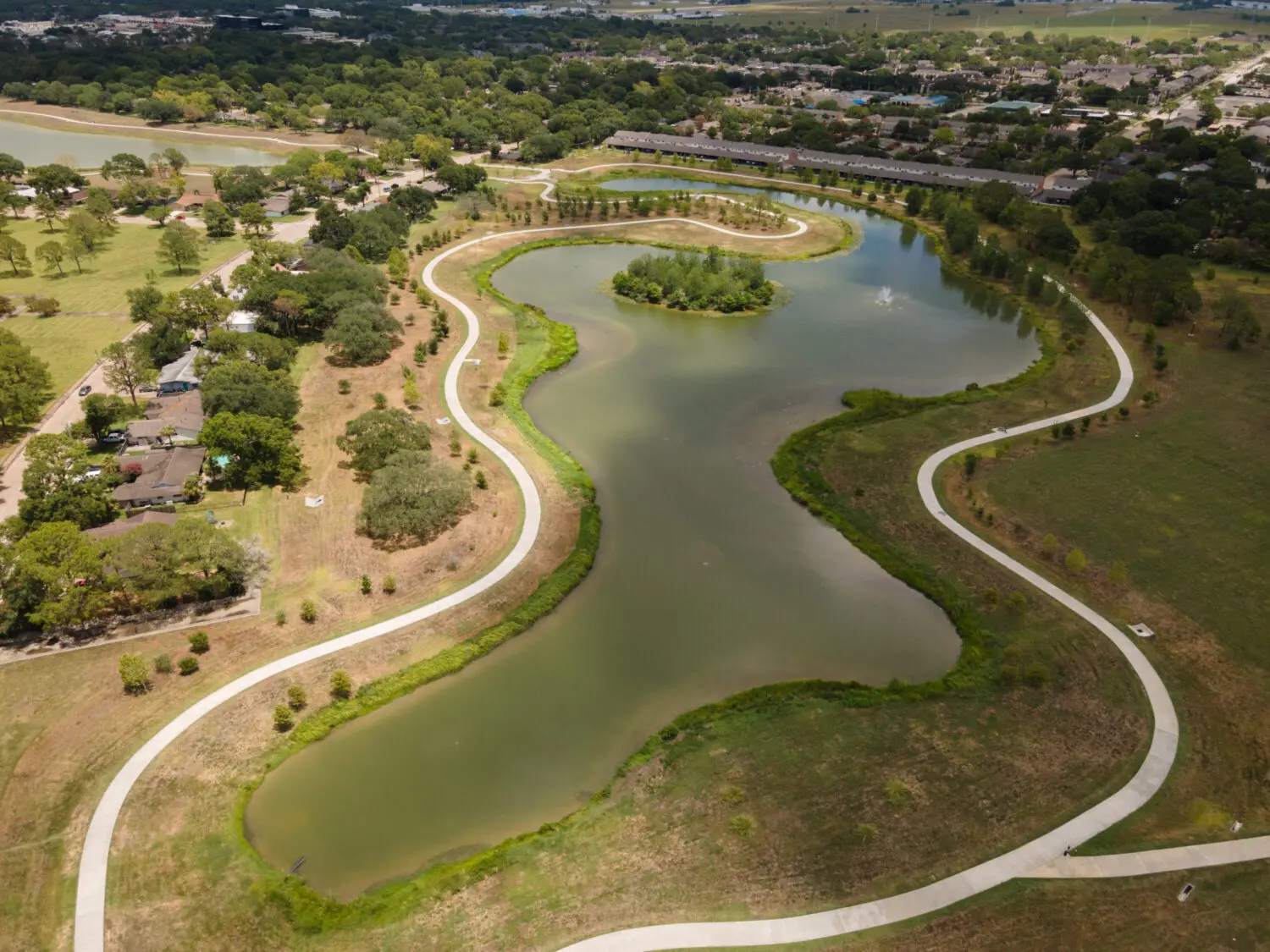
A grand project was developed. The plan called for creating large, natural reservoirs near the most problematic waterways to accept excess water during a flood. These reservoirs were natural bodies of water that were slightly deepened, expanded, and had their banks reinforced. The first phase began at Clear Lake. The result was even better than expected: the area attracted more birds, and the improved landscape became a draw for tourists. Sidewalks around the pond became a popular place for jogging and family recreation. Thus, an engineering solution became a part of a natural oasis within an urban community.
The last of the five natural reservoirs was completed in 2023, costing $43 million in public funds. As demonstrated in practice, this is a sound investment in Houston’s future. During storms, each of the five ponds can hold 100 million gallons of floodwater. At other times, they are tranquil, natural recreational spots.
Flooding Facts in Houston and the Region
Finally, a look at the disaster and its impact in figures and facts:
- Flood damages in the United States have averaged $2.4 billion per year over the last decade.
- In the last 52 years, nearly 1,000 floods have been declared federal disasters.
- Approximately 75% of all federal disasters are flood-related.
- 5 million US residents are protected by flood insurance. The remaining 330 million do not know their available options for protection.
- Over the term of a 30-year mortgage, a home has a 26% risk of being flooded, compared to only a 9% risk of fire.
- The National Flood Insurance Program (NFIP) has paid nearly $16 billion to policyholders.
- Just six inches of floodwater can knock you off your feet or shift your car.
Challenges and Outlook
The flooding problem will never fully recede; that is an accepted fact. Human activity and climate change will only contribute to these events. Authorities in Houston fully understand this. They are therefore continuously improving flood control systems, developing new projects, and modifying existing ones. The experience and observations from previous years will allow them to, if not avoid, then at least significantly reduce the negative impact of this natural disaster.